


Garmin
Garmin US006R U.S. South Electronic Chart
Pickup currently unavailable at Ocean Township
Garmin US006R U.S. South Electronic Chart
Ocean Township
Pickup currently unavailable
3501 Sunset Avenue
Ocean Township NJ 07712
United States
Order Chart
- Integrated Garmin and Navionics content provides exceptional coverage, clarity and detail in a familiar look and feel
- Easy access to daily chart updates is available via the Navionics Chart Installer software or wirelessly via the Plotter Sync feature with the Navionics Boating app (The Plotter Sync feature requires use of the Navionics Boating app on your compatible smart device with an active subscription of the same area.)
- Navionics advanced dock-to-dock route guidance technology uses your boat settings, along with chart data and frequently traveled routes, to calculate a suggested path to follow (Route guidance is for planning purposes only and does not replace safe navigation operations.)
- Downloadable high-resolution relief shading feature combines color and shadow to give you an easy-to-interpret, clearer view of bottom structure than contour lines alone
- Downloadable high-resolution satellite imagery combined with SonarChart Shading overlay give you a realistic view of your surroundings — ideal for entering unfamiliar harbors or ports
Garmin US006R U.S. South Electronic Chart
5.75"
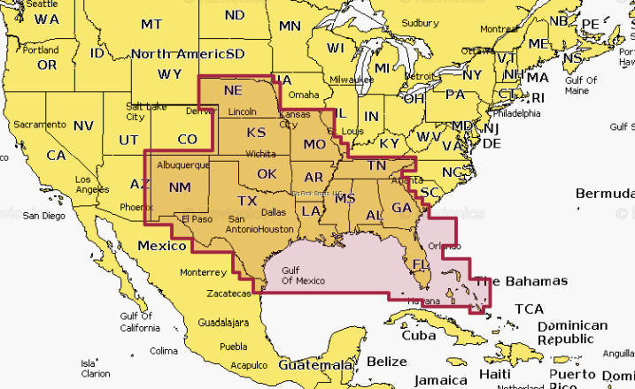
Detailed coverage of the lakes, rivers and coasts of Alabama, Arkansas, Florida, Georgia, Kansas, Louisiana, Mississippi, Missouri, Nebraska, New Mexico, Oklahoma, Tennessee, and Texas. Coastal coverage of the Gulf of Mexico, the Atlantic coasts of Florida and Georgia, the Bahamas and the Florida Keys are also included.